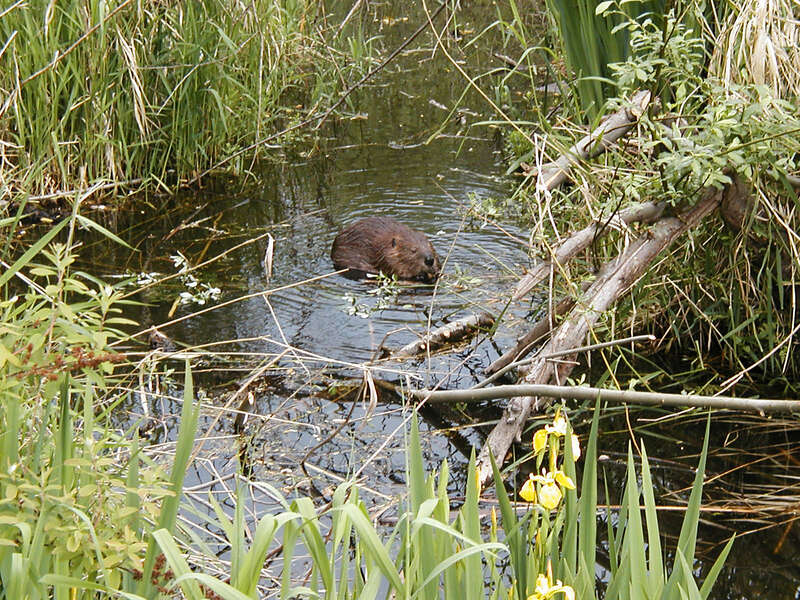
Wildlife
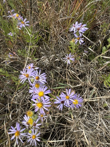
Aromatic aster
Symphyotrichum oblongifolium

Habitat
Big Bend, SD
Conservation
Secure
First Observed
1804-09-21
Very similar to the familiar New England aster, this species has glands on its surface which emit an aroma when crushed.
Recent sightings
Where it’s being seen today
1 research-grade iNaturalist observation between 2024–2024. Most recent: 2024-09-15. Sourced from Terrain360 trail captures, cached locally.
Journal References
15 journal entries mention Aromatic aster
Aug
22
1804
Missouri River near Vermillion area — John Ordway: August 22, 1804
...der a fine Breeze from the South.
1 The Big Sioux rises in eastern South Dakota; it forms the boundary be-
tween Iowa and South Dakota from the northern boundary of ...
Sep
2
1804
Missouri River near Niobrara River — John Ordway: September 2, 1804
...y as yet on the Missouri, in the time or Season
1 Near the eastern boundary of Bonhomme County, S. Dak. The island
opposite which the camp was pitched still retains ...
Sep
4
1804
Missouri River near Niobrara River — John Ordway: September 4, 1804
... Niobrara River; it rises in Wyoming and runs in a general easterly
direction across northern Nebraska.
126 WISCONSIN HISTORICAL COLLECTIONS [Sept. 5
Turkey & one du...
Sep
16
1804
Missouri River near White River — John Ordway: September 16, 1804
...ead lived on grapes."
4 Still so called. It flows in a due easterly direction to the Missouri, drain-
ing much of western South Dakota.
5 In Brule County, opposite t...
Sep
28
1804
Teton Sioux confrontation near Pierre, SD — John Ordway: September 28, 1804
...more of their warries
caught hold of the chord and tyed it faster than before. Cap*
Lewis then appeared to be angarry, and told [them] to Go out of
the Boat and the ...
Oct
1
1804
Missouri River near Cheyenne River — John Ordway: October 1, 1804
...odem Cheyenne, which drains
the Black Hills and Hows in an easterly direction to its junction with the Mis-
1804] SERGEANT ORDWAY'S JOURNAL 145
is about [blank in Ms...
Oct
18
1804
Missouri River approaching Cannonball River — John Ordway: October 18, 1804
...derable stream with two main forks, and flows in
a general easterly direction to its junction with the Missouri.
156 WISCONSIN HISTORICAL COLLECTIONS [Oct. 19
& Buff...
Apr
8
1805
Departure from Fort Mandan, Missouri River — John Ordway: April 8, 1805
...ife River, a stream of some importance, flows in a general easterly
direction to its junction with the Missouri. Near this point is the town of
Stanton, Mercer Count...
Apr
12
1805
Departure from Fort Mandan, Missouri River — Patrick Gass: April 12, 1805
...’’ Mackenzie's Voyage.
These appearances were near the eastern side of the Rocky mountains where they
were crossed by Mr. Mackenzie’s party; and in about lat. ...
Apr
14
1805
Lewis: April 14, 1805
...have remarked that these anamals
generally celect a South Easterly exposure for their residence, tho they
are sometimes found in the level plains.passed an Island,...
May
10
1805
Missouri River Breaks area — John Ordway: May 10, 1805
...om its source in the Rocky Mountains it flows in a general easterly direction
across the northern part of Montana. Lewis describes its water as "about the
colour of ...
May
20
1805
Missouri River near Musselshell River — John Ordway: May 20, 1805
...he members of the expedition.
It is modern Birch Creek, in eastern Chouteau County.
- Named Bull Creek by (lie explorers, but now known as Dog Creek. It is
in Fergus...
Jun
20
1805
Great Falls of the Missouri — John Ordway: June 20, 1805
...ocky Mountains near the continental
divide and flows in an easterly direction to its junction with the Missouri just
above the city of Great Falls. Sun River was dis...
Jun
26
1805
Great Falls Portage — John Ordway: June 26, 1805
...oues identifies it as modern Mitchell
Creek.
3 In the southeastern corner of Lewis and Clark County, a short distance
above Canyon Ferry.
4 The camp was in Broadwate...
Sep
26
1805
Canoe Camp on Clearwater River — John Ordway: September 26, 1805
...ad been descending the valley of modern Jim Ford Creek,
an eastern tributary of the Kooskooskee. Coues locates the camp for the
day on the latter river a mile or so ...